Mineral Mapping
Remote sensing can be utilized in different fields of Geology such as; Mineral exploration, Environmental studies, Hydrogeological modeling, and many more. In mineral exploration Remote Sensing can be used to a set of characteristics of specific minerals deposition that might be used as a guide to similar deposits in the region.
Our datasets include bedrock and Superficial Geological maps, Geophysical survey data, Geochemistry data, and Mineral Occurrence data. Also, a number of line features such as; structural features, fold axes and formation contacts, are present. The Remote Sensing and GIS is the best tool awailable for collecting and integrating all these spatial data.
Objective
The exploring and extracting for minerals is completely GeoSpatial, which makes it easier for Remote Sensing and GIS. Because most of the mines cover wide areas of land, geologists require access to volumes of location-based data to lead the project.
- Target mineral exploration.
- Evaluate mining conditions
- Display geochemical and hydrology data
- Improve facility management and policing.
- Assess environmental impact
- Improve community education
- Effective field work
Benefits of Remote Sensing in mineral exploration
Mineral exploration can be time effective in order to the following factors:
- Combine data and datasets from different sources with ease.
- Link directly from modeling software such as; MapInfo and Leapfrog to database of results ensuring the most recent assay information from analytical testing are included.
- Model quickly and easily in 3D the resource you are exploring from both historical and modern drillhole data stored in database.
- Our way of modeling saves digitizing many different features to be included in the model as it can be interpolated from the drillhole data by the system.
- Fewer hours spent digitizing to incorporate data into models.
- Variety of GIS analysis methods on quantitative and raster data to look for abnormal areas.
- The ability to capture old data of different types and view/analyze as compatible layers. Some of this data would only previously have been examined in paper formats.
- Ability to utilize free historical and modern data in current projects
Our Remote Sensing services allows us to capture, store, manipulate and analyze geospatial data to combine database, mapping and statistical methods to integrate georeferenced data for data collection, processing, and management ensuring accurate solutions that allow you to overcome tough challenges pertaining to your project. Our focus is to deliver accurate quality geospatial products to help manage your mapping goals.
quality control
Our team is committed to quality control and provides continuing geodesy mapping support services to our clients. We ensure that the geospatial data sets provided to our clients are utilized in only the most effective manner. On every GIS project, whether it is large or small, we implement ongoing data quality control to ensure that coordinate databases, foreign source data such as geological and topographic maps, GIS data attributes and layers create a truly seamless in GIS mapping environment.
Deliverables Databases
- ArcMAP
- MapInfo
- Leapfrog3D
- Oasis Montaj
- Discover
We use our in-house knowledge of geodesy, land and hydrographic surveying, 2D/3D digital mapping, GIS, and satellite remote sensing applications to provide the most professional services and products to our clients.
One of the primary services provided by CartoSolution during the implementation of a RS/GIS project is to convert and tranform all data in single platform incliding georeferencing of various GIS data layers for mapping. Cartosolution has developed comprehensive policy and procedures to include QA and QC in the planning stage of every project involving the use of satellite image data for GIS.
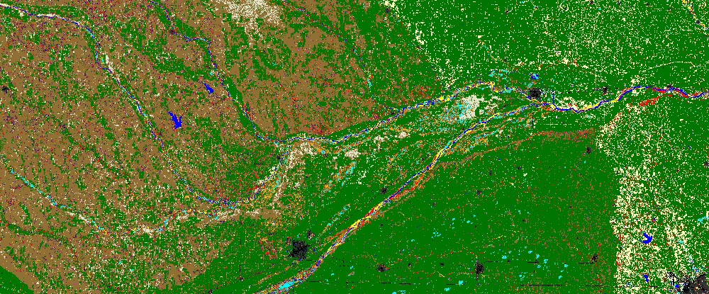
RS/GIS modeling technique for gold exploration
RS/GIS is an effective tool for generating favorability maps for mineral exploration by integrating, analyzing and weighting several exploration datasets. The study aims to locate new extensions for tonalite–diorite (rock) intrusions hosting gold deposits using assimilation of geo-datasets with the aid of weighting approach. This study depend on the assimilation between various data layers, each class within each layer has a specific weight according to its important in mineral exploration. More...